Map of Hong Kong
A map of Hong Kong is a very valuable piece of information for anyone visitng Hong Kong. Once you know where you want to go during your stay, it’s just a matter of mapping out the best spot to get a hotel and planning your day trips with transportation like the MTR, buses, and taxis. If you work all of this out before you arrive, your trip will be much more enjoyable.
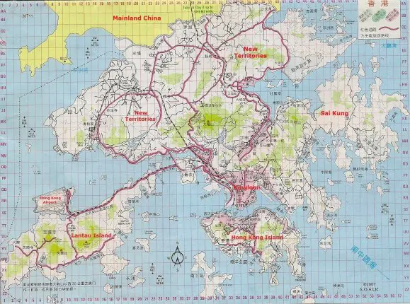
An Island located in the Southern region of Hong Kong. On the map of Hong Kong you can see Hong Kong Island is connected to Kowloon by 3 roads. These are underwater tunnels that run across the Victoria Harbour, allowing cars and buses to drive between Kowloon and Hong Kong Island. Before these underwater tunnels were made, the only way to get across the Victoria Harbour was by the Star Ferry.
Start with the northern part of the Island where you can walk across the southern half of the Victoria Harbour. Causeway Bay, Central and Admiralty provide some of the best shopping available in Hong Kong. This area of the Island, along with Kowloon is known as the heart of the city.
A lot of the most famous attractions and sights in Hong Kong can be found on Hong Kong Island. Take a ride on the Peak Tram for a magnificent view of Hong Kong from Victoria Peak, the highest viewing point in the city. Travel to the southern ends of the island for popular attractions including Ocean Park, Stanley, and Repulse Bay.
The northern part of Hong Kong Island is serviced by one of the oldest forms of transportation in Hong Kong, the Tram. The Tram is the world’s largest fleet of double decker style tram carts currently in operation. It’s very cheap at $2.30 HKD for an adult ride.
Kowloon is a Peninsula in Hong Kong located north of Hong Kong Island and south of the New Territories.
Kowloon has so many people living in such a small area that it is known as one of the most densely populated parts of the world. The areas coloured pink on the map of Hong Kong represent the highly populated spots of the city. You’ll notice that most of the pink areas on the map of Hong Kong are found in Kowloon. Almost half of the people who live in Hong Kong live in either Kowloon or Hong Kong Island.
Kowloon is a very busy area. Here you’ll find lots of shopping malls and markets selling anything from clothing to electronic devices and computers. Finding somewhere to stay in Kowloon is very easy as hotels ranging from luxury 5 Star Hotels to cheap hotels can be found all over the place. A wide variety of museums can be found here as well.
The old Hong Kong International Airport used to be in Kai Tak, Kowloon. Because airplanes would land here, a height restriction was put on buildings in this area to make sure no airplanes crashed. If you come to this part of Kowloon you’ll see that a lot of the buildings are much shorter than the rest of Hong Kong.
Attractions include the northern half of the Victoria Harbour in the southern region of Kowloon. Here you can walk down The Avenue of the Stars, take the Star Ferry across to Hong Kong Island, and come back at night to witness A Symphony of Lights. Visit Kowloon Park for a peaceful escape from the loud city streets.
The name Kowloon means “Nine Dragons,” representing the 8 mountains that overlook Kowloon. The 9th dragon is said to be the Emperor who counted the mountains. The most famous mountain, Lion Rock, is named after its resemblance to a lion.
The New Territories is the biggest region of Hong Kong. It spans more than 200 islands and all of the other pieces of land in Hong Kong that surround Kowloon and Hong Kong Island. This includes Lantua Island and Sai Kung on the map of Hong Kong.
Most of the areas in the New Territories are rural, making this part of Hong Kong a huge contrast to the very urban areas of the other 2 regions. If you’re looking for somewhere that’s a little more relaxing and slower pace than the bustling city, the New Territories are a great spot for you.
The bulk of activities in this area are parks, hiking trails, temples and a few museums. There are some malls scattered across this larger region as well, but not as extensive as the more urban regions.
One of Hong Kong’s favourite sporting events is horse racing. You can visit the Sha Tin Racecourse to watch the horse races and even place some bets on which horse you think will win the race. This is sure to be an exciting experience for anyone who attends. Special MTR routes to the racecourse run on race day for anyone who wants to see the races in person.
Lantau Island is the biggest Island in Hong Kong. On the map of Hong Kong you can find it in the eastern region of the city. It’s also part of the New Territories. Lantau Island has a fairly low population compared to the rest of Hong Kong.
In recent years Lantau Island has become a very important part of Hong Kong. With many major attractions and infrastructure built on this Island. The most important one being the new Hong Kong International Airport located at Chek Lap Kok (the north western part of the Island on the map of Hong Kong). As well as many bridges connecting Lantau Island to the major parts of Hong Kong.
Here you’ll find Hong Kong Disneyland and the Ngong Ping 360, two of the most famous attractions in Hong Kong. Some great shopping can be found at the Citygate Outlets, the only Outlet Mall in Hong Kong. The AsiaWorld Expo convention center is close to the Airport. Several national parks and hiking trails can be found on Lantau Island as well.
The best part about Lantau Island is that all of the things to do are located very close to the Airport. So if you have some time to kill while you wait for your next flight leaving Hong Kong, you don’t have to go very far to find activities, tourist attractions and shopping.
Sai Kung is a popular area found on the eastern end of the New Territories. It’s mainly a rural area with a slower pace than the much more urbanized areas of Kowloon and Hong Kong Island.
What makes the Sai Kung area popular is the large amount of fresh seafood available here. Sai Kung Town has many seafood restaurants along the street next to the waterfront. Here you can enjoy some of the best seafood in Hong Kong. Walk along the piers and order live seafood from off of fisherman’s boats. You’ll see lots of tanks filled with live sea creatures in front of nearby restaurants as well. You can pick your meal from these tanks and take it in to one of these restaurants to have it cooked for you. Seafood can’t get much fresher than eating it the day it was caught in the Ocean.
Another popular activity in this area is to rent a boat and go fishing for squid and cuttlefish. You’ll notice on the map of Hong Kong there are a lot of islands in the Sai Kung district. You can rent a boat to visit some of these secluded islands. Golfers can tee off at the public golf course found on Kau Sai Chau Island. A lot of parks, museums and temples can be found in the Sai Kung District as well.
Out here you’ll find Tseung Kwan O, a fairly new urbanized part of the Sai Kung District. Most people who live in Sai Kung live in Tseung Kwan O, making it the most populated part of this region. You’ll find many new high rise buildings out here. Because of all the people who live in Tseung Kwan O now, the MTR has been expanded to reach this area. The famous TVB Chinese television station is inside the industrial estate in Tseung Kwan O. If you’re interested in seeing the TVB station, they have tours open to the public.
Travelling to most spots in Sai Kung takes a little longer since the MTR only goes to Tseung Kwan O. From here you’ll need to take a bus or boat to get to any of the other areas of Sai Kung. Some of the small Islands can only be reached by boat.
The yellow area on the map of Hong Kong is Mainland China. China is located north of Hong Kong.
Things become a little more difficult if you go to Hong Kong and want to visit China. Hong Kong will let you in with your passport, but China will not. In order to get into China you must apply for a Visa. Once you have a Visa, China will grant you access to their country. Make sure you have the Visa on you at all times.
A popular city in China for travellers to visit from Hong Kong is Shenzhen. On the map of Hong Kong it says that you can take a day trip to Shenzhen. Shenzhen is very close to the border separating China and Hong Kong, making it easy to go there for a day and come back.
The streets of China are not as safe as the ones in Hong Kong, so make sure to be a little more careful here.